Parts of NSW continue to feel effect of last years floods with more rain to come
The creek that runs near Helen Rogers' property in the NSW Southern Tablelands is teeming with water and pelicans - a sight she hasn't seen since 2016.
The Middle Creek in the Lower Lachlan Valley region, which only gets water when the Lachlan River floods, has been flowing since October last year when much of the state was deluged, causing flooding in nearby towns such as Forbes.
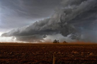
Severe storms hit parts of far west NSW, the Riverina and Victoria on Saturday. Credit:Nick Moir
With more wet weather on the way in the coming days, forecasters and water authorities are turning their attention to how the already sodden water system will cope.
"It's a lovely sight. It's amazing to see it when it first comes down and how much the water just creeps along the riverbeds and fills up little bits," Ms Rogers said of the full creek.
It's a welcome sight for Ms Rogers who said the area was hit hard during the 2002 to 2010 drought, and again during the 2018 to 2020 drought.
"When there's no water running through, it's just normal country, but when it does go through, we'll probably have 12 months to two years of feed [for the animals]. It is the way of life out here; you have to take the good with the bad."
Sydney has sweltered through another hot and humid day ahead of cooling conditions overnight.Credit:Nick Moir
The Lachlan River and many other waterways across the state are close to capacity or full. Total rural storage levels are at 94 per cent, compared with 49.9 per cent this time last year. Meanwhile, dams in the Greater Sydney catchment are at 96.4 per cent capacity.
WaterNSW said it had been working closely with the Bureau of Meteorology and, at times, the NSW State Emergency Service to monitor the weather and dam inflows.
"For several months WaterNSW has been making substantial dam releases between rain events to lower key dam storages and prepare to capture inflows from the next forecast rain event," a statement from the agency said.
"Dams such as Burrinjuck on the Murrumbidgee River and Wyangala on the Lachlan River have received inflows equivalent to more than the entire dam storage since mid-2021."
Parts of NSW are preparing to get up to 100 millimetres of rain across the next four days.
Bureau forecaster Morgan Pumpa said a trough was moving from the west of NSW to the north-east, bringing large amounts of tropical moisture and heavy rainfall to parts of the state, particularly in the Northern Tablelands and Northern Rivers regions.
"The trough could bring widespread rain with some embedded thunderstorms to parts of the north-east," she said.
"Current forecasts say there will be widespread rain with totals of between 20 and 60mm in the north-east, but there will be some isolated locations that may see between 50 and 100mm.
"There is the risk of possible flooding in the area north-east [of the state] in places like the Bellinger, Tweed and Wilson rivers."
While some parts of the state have sweltered during the past few days, a cold front behind the trough is expected to offer some relief. In Moree, temperatures hit 40 degrees on Tuesday but will drop to 24 degrees on Wednesday night.
Similarly, in Sydney's west, temperatures hit 35 degrees in Penrith on Tuesday but will drop to 21 degrees overnight. Sydney city is expected to see a drop from 31 to 20 degrees overnight, with 3 to 10mm of rain forecast for Wednesday.
It comes as climate models suggest La Nina is near or at its peak, with a return to a possible neutral El Nino-Southern Oscillation status in autumn.
The climate driver known as the Southern Annular Mode index has recently risen to positive levels, with forecasts expecting to see it remain positive before gradually weakening in the next three weeks. This could bring wetter weather to eastern parts of Australia, but drier than average conditions for western Tasmania.
However, most La Nina weather events bring flooding rains before they move off, with experts unable to rule out whether the same will happen this year. It is a possibility that forecasters and the SES are preparing for.
Since October 1, last year, the NSW SES has responded to more than 18,000 requests for assistance - the vast majority of which have been storm-related.
The Morning Edition newsletter is our guide to the day's most important and interesting stories, analysis and insights. Sign up here.
Belum ada Komentar untuk "Parts of NSW continue to feel effect of last years floods with more rain to come"
Posting Komentar